Home Multi-Country Search About Admin Login
Cenozoic
Mesozoic


Information provided by geoscience team at Ahmadu Bello University, Zaria, Nigeria --see About

Search by
Select Region(s) to search
Hold Ctrl (Windows/Linux) or Command (Mac) to select multiple
Ronier Formation
Click to display on map of the Ancient World at:
Ronier Fm base reconstruction

Ronier Fm


Period: 
Cretaceous

Age Interval: 
Aptian


Province: 
Chad S

Type Locality and Naming

Bongor Basin (SW Chad). The upper member of the Ronier Fm is relatively intact and outcrops in the southern part of the basin, with outcrops in the central part and in the Ronier-1 and Naramay-1 wells.

Synonym:

Reference: Chen et al., 2018; Wang et al., 2022; Dou et al., 2023

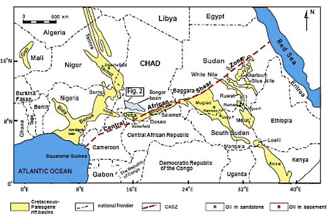
[Fig. 1: Simplified map of the West and Central African Rift System (WCARS) showing the major features discussed in the text and the location of the Melut Basin in South Sudan (modified from Genik, 1993)]

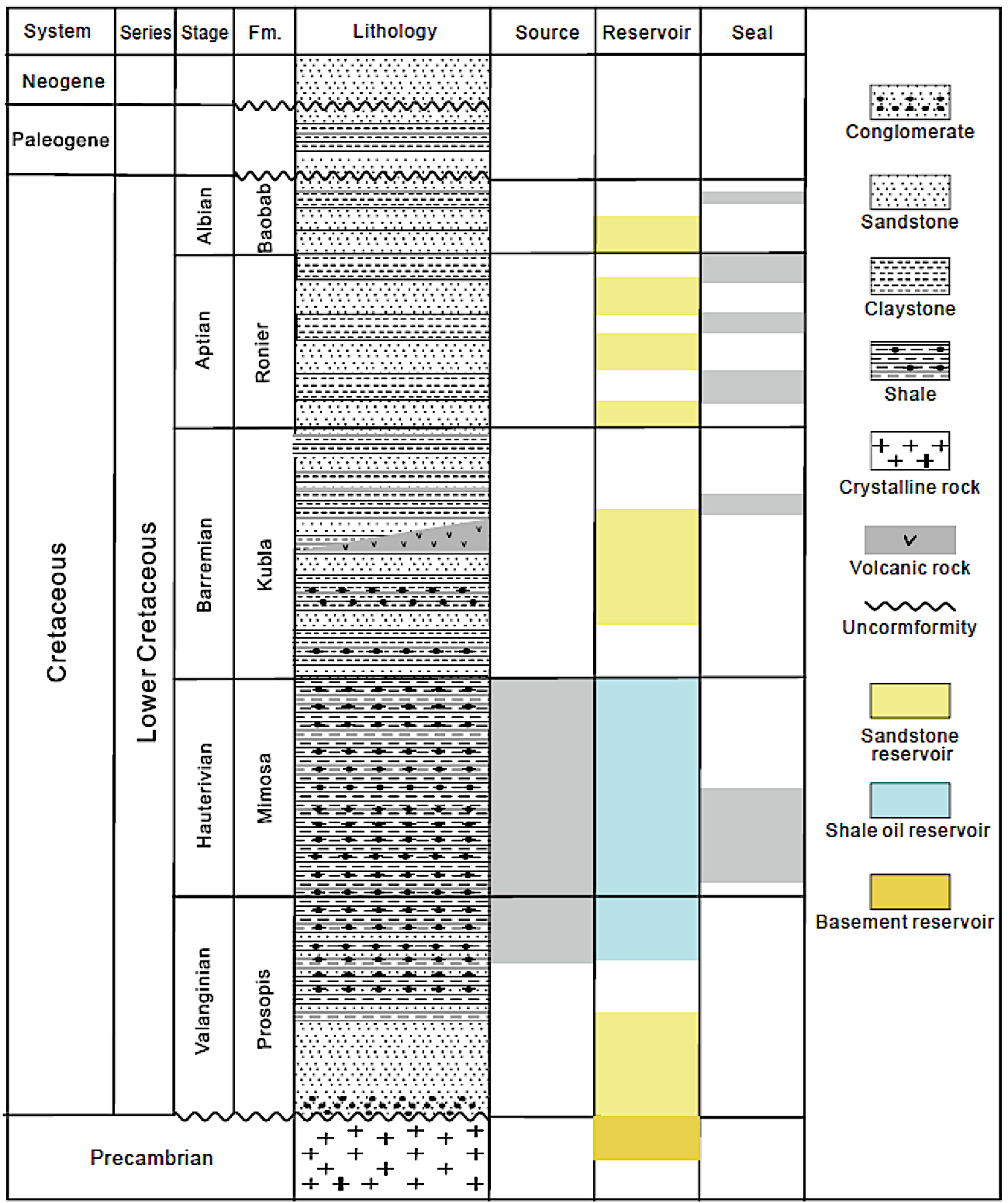
[Fig. 2: Stratigraphic chart for the Bongor Basin showing the positions of producing reservoirs, source rocks and seals (from Dou et al., 2020)]


Lithology and Thickness

Thick bedded, massive, weakly consolidated medium to coarse-grained sandstones. Pebbly coarse-grained sandstones interbedded with mudstones and black basalt (Chen et al., 2018; Wang et al., 2022). The Ronier Formation can be divided into lower and upper members. The upper member is severely denuded, or even missing, in the north part of the basin but relatively intact in the southern part of the basin, with a maximum residual thickness of nearly 1800 m. The central and southern parts of the basin are dominated by fine lithofacies containing a large set of mudstone intercalated with thin siltstone-fine sandstone deposits. The deposits in the northern are mostly a large set of fine sandstone to gritstone, with occasional mudstone and shale (Dou et al., 2023).


Lithology Pattern: 
Coarse-grained sandstone


Relationships and Distribution

Lower contact

conformably rests on the Kubla Fm

Upper contact

Baobab Fm conformably rests on the Ronier Fm

Regional extent

Bongor Basin (SW Chad).


GeoJSON

{"type":"Feature","geometry":{"type":"MultiPolygon","coordinates":[[[[19.4,9.82],[17.92,9.36],[17.18,9.44],[15.36,9.97],[14.78,10.73],[15.25,11.38],[16.26,11.23],[17.7,10.81],[19.4,9.82]]]]}}

Fossils

Pollens (Leiotriletes, Concavisporites, Cyathidites minor, Lygodiumsporites subsimplex, Pilosisporites, Cicatricosisporites subrotundus, Cicatricosisporites gushanensis Li, Cicatricosisporites gracilis, Cicatricosisporites exilioides, Cicatricosisporites augustus Singh, Cicatricososporites potomacensis, Cicatricososporites, Interulobites triangularis, and Schizaeoisporites), Ostracods (Cypridea cf. yabulaiensis, C. cf. simplex, Mongolianella sp., Trianulicypris sp. Darwinula sp.,)


Age 

Aptian

Age Span: 

    Beginning stage: 
Aptian

    Fraction up in beginning stage: 
0.00

    Beginning date (Ma): 
121.40

    Ending stage: 
Aptian

    Fraction up in the ending stage: 
1.0

    Ending date (Ma):  
113.20

Depositional setting

Fluvial delta – deep to semi-deep lake (Chen et al., 2018; Wang et al., 2022).


Depositional pattern:  


Additional Information


Compiler:  

Enam O. Obiosio, Solomon Joshua Avong and Henry Nasir Suleiman (2024) - Stratigraphic Lexicon compiled from the following books:

Chen L., Ji H., Dou L., Du Y., Xu Z., Zhang L. (2018): The Characteristics of Source Rock and Hydrocarbon Changing Time of Precambrian Granite Reservoirs in the Bongor Basin, Chad. Mar. Petroleum Geol. 97, pp. 323-338

Wang Y., Xu G., Zhou W., Liang J., He S. (2022): Predicting Granitic Buried-Hill Reservoirs Using Seismic Reflection Data – A Case Study From the Bongor Basin, Southwestern Chad. Frontiers in Earth Science, pp. 1-13

Dou L., Xiao K., Wang J. (2023): Petroleum Geology and Exploration of the Bongor Basin. Petroleum Industry Press.